Boston and it’s metro area is anywhere from the 6th to the 21st most populous in the United States, depending on how you define the metro region. Though Boston isn’t a top-5 metro in size, it’s rapid transit system reflects the region’s outsized influence and dynamism.
Boston’s T System

4th
Highest ridership in the U.S. - 210 million annual riders*
3rd
Most stations in the U.S. - 130 light/heavy rail or fare-controlled stations
64
Miles of Rapid Transit Track
1897
Year the Tremont tunnel opened - the oldest subway in North America

Official MBTA Subway Map
Soon after arriving and navigating Boston, I realized the T offers a confusing multitude of technologies and transit experiences:
The Green Line
Light rail cars that run below ground, in trenches, through tree-lined street level medians, open medians, and with street traffic. Some sections are fare controlled and some sections require payment upon boarding.
The Blue Line
Narrow heavy rail cars that run at grade or elevated with catenary cables, and below ground powered by third-rail in the city center. Fare-controlled throughout.
The Orange Line
Wide heavy rail cars that run below ground and at grade. Fare-controlled throughout.
The Red Line
Wide heavy rail cars that run below ground, elevated, and at grade. Fare-controlled throughout.
The Silver Line (fare controlled section only)
Dual-mode buses that run on catenary cables below ground and at grade. Fare-controlled through tunnel.
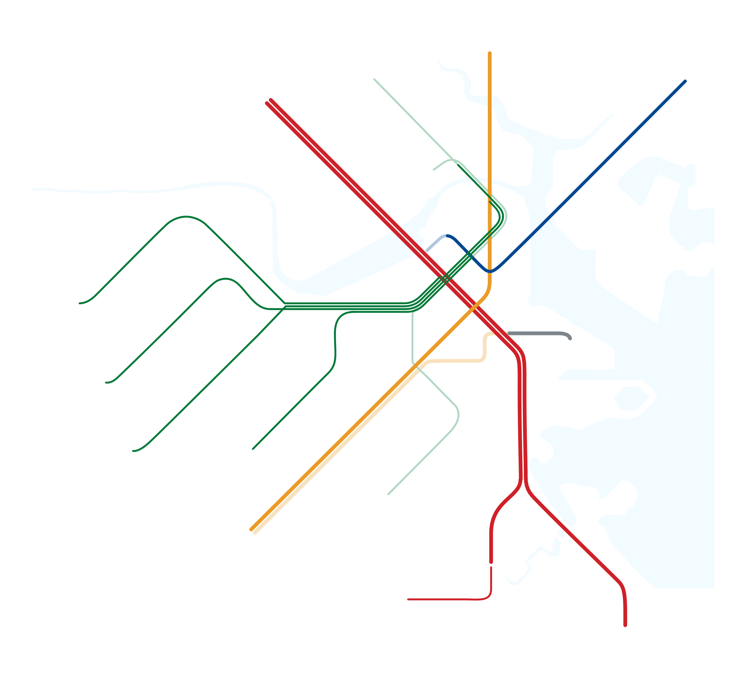
This led me to think about other ways to represent the unique experiences the T offers, and how that could be conveyed in the system’s most visible resource, the MBTA map. I focused on visually representing each line from it’s origin to it’s terminus, and also modifying the line width based on the transit type, with green line light rail cars being thinnest, narrow blue line heavy rail cars are thicker, and the wide orange and red line heavy-rail cars are represented as the thickest lines.
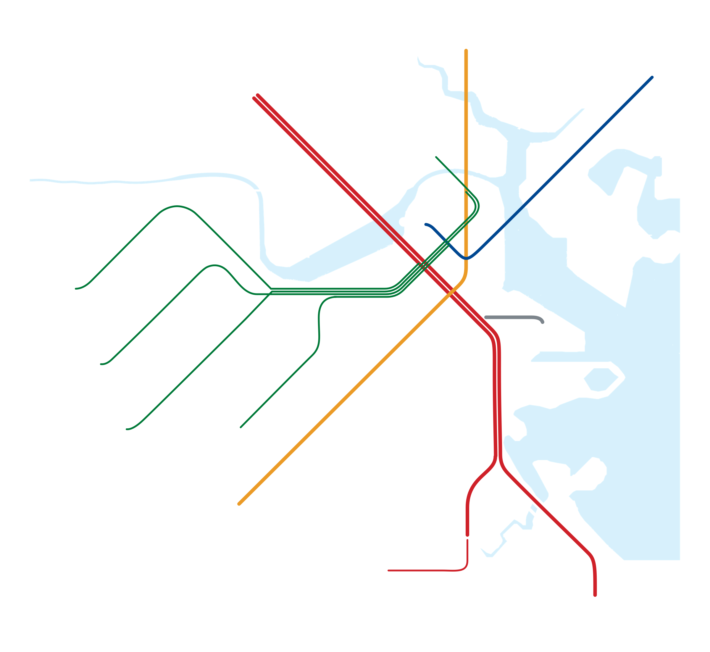
Rapid Transit Lines - Today

Rapid Transit Lines - Upon Completion of the Green Line Extension

In order to clarify expectations for T riders, I designed this map with the intention of better communicating the experience of Boston’s myriad transit lines, whether you’re riding Bus-Rapid-Transit, Heavy-rail metro cars, or fare-controlled lightrail.
FUTURE BOSTON TRANSIT
Many T projects are presently focused on service quality and consistency. Once day to day service issues are addressed, what might the T system look like over the next decade? I researched prior mbta proposals, examined connectivity challenges and densely populated areas that are underserved, and put together a map that explores what the T subway system might look like in 2030.
The below map shows the T with a blue and red-line connection at Charles/MGH (utilizing the existing Cambridge St tunnel), a Washington St streetcar line that serves Roxbury via the existing Tremont tunnel to Eliot Norton Park, and the retrofit and extension of the Silver Line tunnel to join the Orange Line.


Represented over Boston’s geography
Another more ambitious strategy over the next decade might cost significantly more in the short term, but significantly reduce costs and improve efficiency in the future.
In the below map Kenmore Sq and Copley would become transfer stations for the present green line streetcars, which would restrict the less predictable transit times (due to streetcars running with traffic and passengers waiting to pay) to only a portion of the present green line. The rest of the green line could be retrofitted to heavy rail for faster movement throughout central Boston and Somerville, and prioritize fleet commonality with either the Red/Orange train cars or the Blue line, allowing for cost savings through more efficient resource allocation. System expansion could prioritize the new green line heavy rail.

Could this fill in Boston’s existing rapid transit coverage over the next decade?